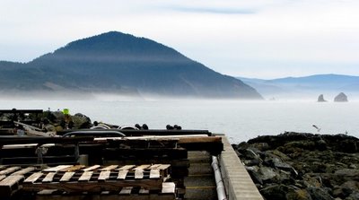
 What you see in the foreground is the southern end of the dock at Port Orford, with assorted pallets and equipment taking up parking spaces along the western edge. To the right, atop the jumble of jetty rock, you can see a gull coming in for a landing. (If you left-click on the photo, you can see a larger version.)
What you see in the background is the view I had for a good share of my childhood -- Humbug Mountain. Six miles south of Port Orford and rising 1756 feet right out of the ocean, Humbug has a reputation for being a sort of weather barometer around here. You can see a thin strip of fog across Humbug's face, like a gauzy scarf, and you can see low-lying ground fog along the beaches, all reflective of the overcast day but nothing to alarm anyone. It's when the sky lowers itself down and lays a cap on Humbug's head that we know the nasty weather is near upon us.
I won't swear to the details of this story but apparently it used to be known as Sugarloaf Mountain. Supposedly, a party was sent out to explore the mountain. Unfortunately, they pointed themselves north of Port Orford instead of south, based, it's said on false information -- or humbug. The term gradually became the accepted name for the mountain. I find that kind of mistake hard to believe when you see how visible the durned thang is. Another story claims miners were zeroing in on the black sands near the mountain because of rumors of gold -- which turned out to be a humbug claim. That sounds closer to the truth.
But we'll probably never really know -- and I like that. A little mystery leaves wiggle room for one's imagination and that's a Good Thang.

4 comments:
A bit of mystery and a good humbug certainly helps things along, Dee! If that's a recent photo it shows the truth of my current mantra--Spring is on the way...:0)
Spring is on the way??? Where??? (turning head around in circles).
Beautiful Mountain and a great story to go with it. We don't have a 'Humbug' Mtn here, but we do have a 'Sugarloaf'. Sometimes its referred to as Baldy Mtn as there are no trees on the top, only rock.
I don't recall seeing this Mountain. Were we at this area of Port Orford?
Speaking of turning around in circles, the Oregon State Parks site for Humbug Mountain has some interesting 360 degree panoramas of the site du jour. Never take rocks for granite.
Post a Comment